According to one of my previous post (Collaborative City), the real change on how we interact with the city will come when we will be able to establish a dialog with it or its parts. The city will have become then a sensitive entity being able of taking decisions, performing and communicating, due to an intelligence distribution and calculation capacity process among all its components.
We call urban Component every element in the city taking own space up, regardless of the fact it is static, moving, material or non-material. A space attached to the Component by virtue of a legal, administrative or functional assignment, in an explicit or public manner.
As an example we will take one Public Space –the road is a link for public use. All the space in a public urban road is not legally differentiated, it is usually on the Urban Property Registry, showing partially and fragmented in multiple pieces, as they have been added to the public urban property throughout time.
Public space legal structure is not thus essential information, except for demonstrating it is actually a public property. This continuous and even space is so vast that it is unusable, the urban administrator needs to break it up under geo-administrative and political criteria –“public road stretches” are assigned a type (avenue, walk, street, alley…)–, a name and a size, intending that all important figures will enjoy their own “fame corner”, and should all of them be satisfied, imagination or historical toponymy will be applied.
When two or more roads intersect, there are two possible strategies to apply –the intersection will become a public road stretch (square), the intersected stretches being fragmented, or they are simply ignored, so the intersected stretches lay superimposed (a long stretch is usually fragmented as a result of this intersection, so further important figures may take their place.)
So far, we can come to the conclusion that usual public space fragmentation is not based on functional criteria; its type would even show a few data on its functional configuration.
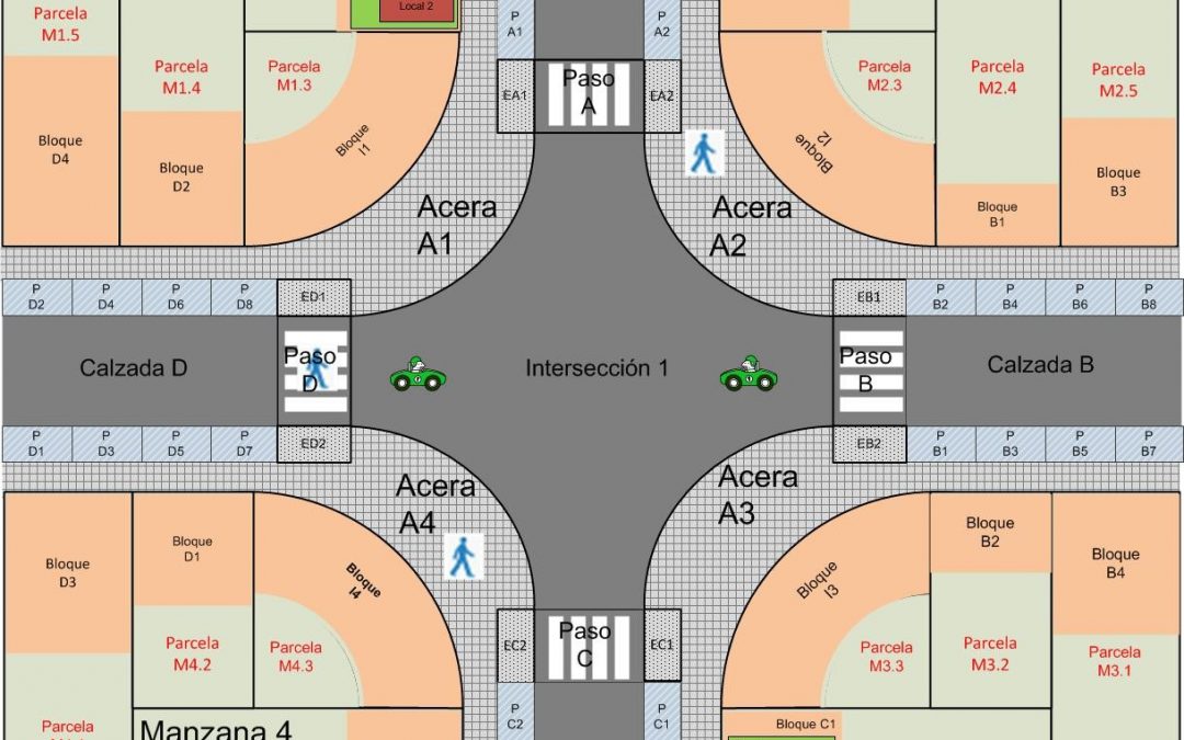
From a strictly functional overview, public space is actually divided in six types of areas:
- The road: an area reserved to vehicle traffic flow, distributed in internal lanes and assigned to every type of vehicle and direction. Every lane is provided of a waiting platform linked to an entrance or intersection.
- The pavement: an area reserved to pedestrian flow, distributed in two sub-types, walking areas and waiting platforms. These platforms are focused on pedestrians crossing a linked entrance.
- The entrance: a mixed area where vehicles and pedestrians of waiting platforms from linked areas, roads and pavements running perpendicular interact. Flows rotate, as the entrance cannot be simultaneously occupied by both of them. There are usually two types of entrance, crosswalks and pavement curbs for vehicles accessing properties around.
- The intersection: a converging area where flows rotate between the linked roads based on a temporal scheme.
- The parking bay: an area that a vehicle temporarily uses.
- Non-specific area: area not having a concrete function or may be considered as a barrier; they are decorated and paved.
All areas on the public space are distributed by these six types, making a patchwork, a puzzle from different pieces filling it up:

Isolating every piece and assigning its own particular area to it will let us get Urban Components. Let’s suppose all of them, every piece of road, pavement or intersection, along with all the magic of technology, is provided with special capacities:
- The first stage is providing it with identity –a name or an ID, which is particularly attached to it and makes it unique. It is important, so it will be distinguished from others. If you ask to the entrance “Can I go on?” –you are not asking to all entrances, but the one standing in front of you, the damn entrance V34-43, which has it in for you.
- A tridimensional space is assigned to it, being able to control its limits to avoid unauthorized users coming through by any means.
- It will be conscious about its neighboring areas, so it can interact. This damn entrance V34-43 receives flow requirements from the pavement, which has got a few pedestrians on its waiting platform, or from the road, that also has some vehicles waiting for the intersection response to go through, although they will not permitted until the first remaining requirement from the pavement will be satisfied.
- The entrance keeps usually still, but it might move like a car or a pedestrian, so it would have an accessible area and a trajectory. Actually, the entrance has an accessible area, but it remains the same as its own particular area! So it can hardly move and its trajectory with length 0.
- The entrance is an area called Conductor –it makes other components, like the pavement or the road move, unlike the intersection, which is a component called Distributor, or the plots, which are Containers.
- The entrance is a municipally owned utility, its management delegate focuses on providing it with activity and dealing with its complaints. It does complain very often –“there is too much traffic flow and everyone is yelling at it, but it is not its fault”, “pedestrians run on it without permission”, “that old paint looks awful on it”… It was created during a urbanization work project a few years ago (Geotransactions), but it will probably be out of order soon, as that street is said to be renovated. Relocating it to a new entrance would be beneficial for it, even though it may have its version upgraded.
- It deals with external requirements –“we need your monthly pedestrian and vehicle flow report,” “block everyone’s way except vehicle M34567’s, since a major figure will go on through,” “please send us your 2D-geometry in order for you to appear on a map…”
- You should be cautious about it. It tends to report every vehicle or pedestrian not complaining with the rules. However, it is responsible when responding to an incident or breakdown, a pedestrian falls down or someone just asks it for help on its area; it is designed to do everything in its power to help.
All this is made because the entrance is an intelligent agent, working in the cloud and connected to its sensory system and its neighbors, vehicles and pedestrians through the Internet. As an intelligent agent, it actively participates in creating traffic flow optimization strategies in neighborhood committees and district assemblies. Well, it is a very busy entrance!
Madrid has lots of millions of urban components, which might become intelligent parts in the city one day —who knows!—, a kind of special “citizens”. We are committed to solve minor problems and generate an emerging performance, a “city behavior” possessing a particular character: the conscious city.
On other posts, we will describe how many urban component types exist in the city, how they react and how they can be seen thanks to Location Services.
Ignacio Arnaiz Eguren – Innovation Director– Arnaiz Consultores SL